Extrinsic Transformation#
This is useful if you want to transform the camera's output data into a coordinate system that fits your application.
Using the Feature#
How It Works#
The position and orientation of a blaze camera's coordinate system is fixed. Its origin is the optical center of the camera, with the z axis pointing away from the camera. This coordinate system is called the anchor coordinate system.
The blaze camera allows you to transform the anchor coordinate system into a transformed coordinate system as required by your application.
Transformations use Cartesian coordinates in the x, y, z notation. The transformation values define the transformation from the anchor to the transformed coordinate system.
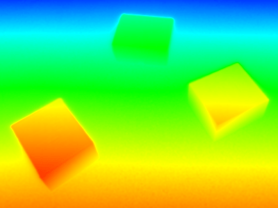
The first image below shows a depth map colored based on the distances in the anchor coordinate system. The second image shows a depth map based on the distances in the transformed coordinate system.
The transformed coordinate system is chosen so that the z axis is perpendicular to the surface on which the boxes are placed. That way, the boxes all have the same z value.


Another use case is to simplify the matching and fusion of data from multiple cameras by transforming their individual coordinate systems into a common coordinate system.
The transformation from the anchor to the transformed coordinate system is done by performing a rotation and then a translation.
The rotation is defined by the rotation angles around the x, y, and z axes. The translation is defined by the displacement ThX, ThY, ThZ to the new origin.
The coordinate transformation is therefore defined by a total of six parameters.
The effect of the transformation differs depending on the component:
| Component | Effect of the Transformation |
|---|---|
| Range | For point clouds, i.e., the PixelFormat is set to Coord3D_ABC32f, the transformation is applied completely. For depth maps, i.e., the PixelFormat is set to Coord3D_C16 or Mono16, the transformation is not applied. |
| Intensity | Not applied. |
| Confidence | Not applied. |
Performing an Extrinsic Transformation#
- Set the
Scan3dCoordinateSystemReferenceparameter toTransformed. -
Set the
Scan3dCoordinateTransformSelectorparameter to the desired transform value.Use the
TranslationX/Y/Zvalues for tranlastion and theRotationX/Y/Zvalues for rotation. -
Set the
Scan3dTransformValueparameter to the desired value.The value for translations is expressed in the distance unit of the system. The value for rotations is expressed in degrees.